Proposals
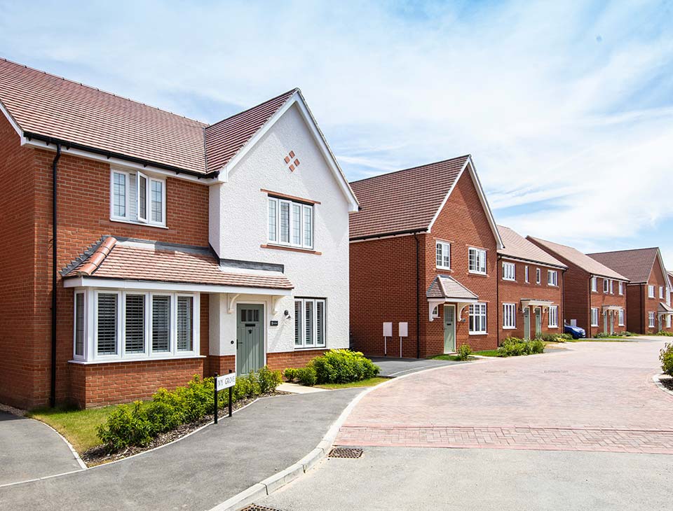
High-quality homes and landscaped open space
Bloor Homes is progressing a Full Planning Application for the site at High Lane. As such, details of access, design, scale, layout, landscaping are to be considered at this stage.
The proposals include 57 new high quality homes of which 35% will comprise of affordable housing tenures set among green open space, increasing biodiversity in the area, and encouraging active travel links for the new and existing community.
Key features
Benefits for the community and local area
- A mix of 57 high quality new homes.
- 35% will be affordable tenures including family homes, maisonettes and bungalows.
- At least a 10% Biodiversity Net Gain (BNG).
- Use of sustainable building practices, air source heat pumps and the provision of electric vehicle charging points.
- Opportunities to enhance connectivity along High Lane, aiming to improve access and ease of movement for the community.
- Publicly accessible landscaped open space.
- Sustainable Drainage System (SuDS).
The site
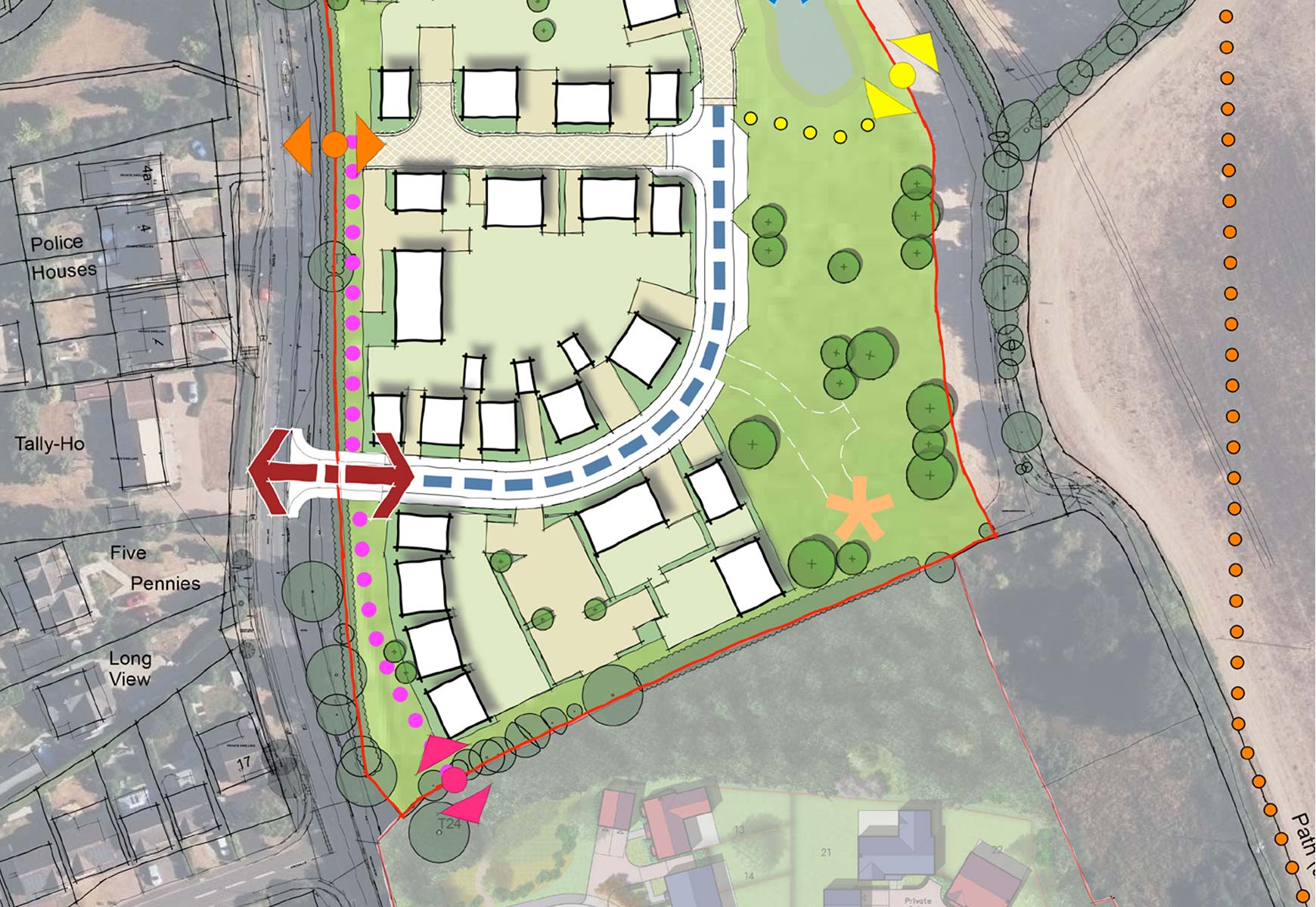
Site location and masterplan
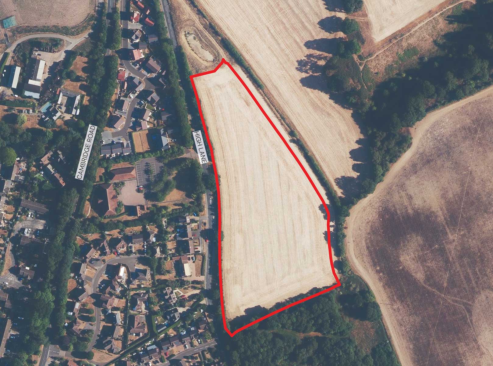
The site lies to the east of High Lane on the north eastern edge of Stansted Mountfitchet, and comprises approximately 2.58 ha of land. It is formed of a roughly triangular single parcel which gently falls to the east away from High Lane.
The site’s location adjacent to the existing settlement edge places the hub of facilities that Stansted Mountfitchet offers within a 15-minute walk of the proposed development via pedestrian connections on High Lane.
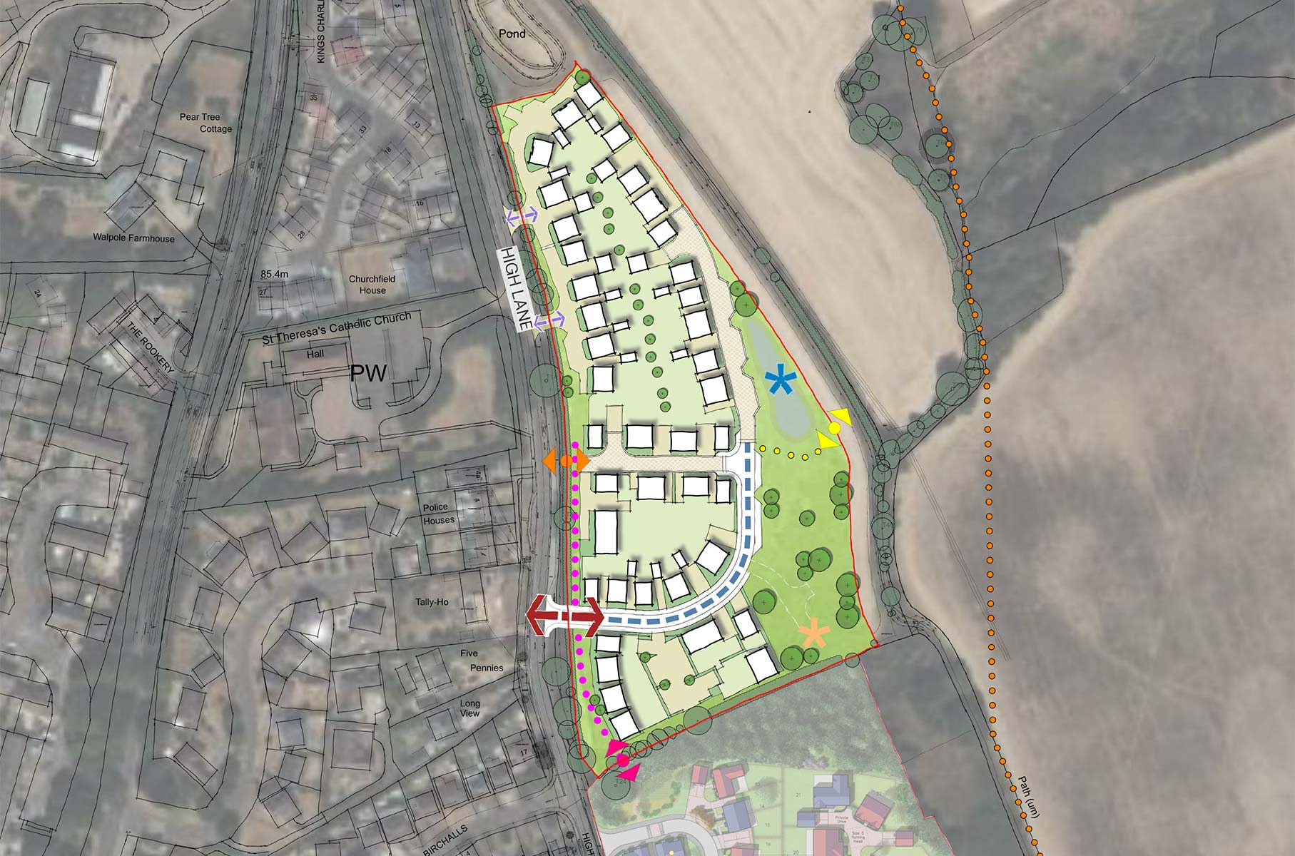
 Site location
 Residential dwelling
 Proposed vehicular access off high lane (subject to highway input)
 Proposed private vehicular access off high lane (subject to highway input)
 Potential point of connection to existing wider prow network
 Indicative pedestrian crossing
 Pedestrian connection to southern development
 Proposed primary street
 Proposed shared surface street
 Proposed private drive
 Existing public right of way (PROW)
 Informal pedestrian route to potential PROW connection
 Proposed pedestrian route
 Public open space
 Existing vegetation/ trees
 Indicative proposed trees (subject to landscape strategy)
 Indicative location for sustainable drainage feature
 Indicative pump station location
Landscaping and open space
Encouraging active lifestyles and increasing biodiversity
A landscape-led approach has guided the development to assist with assimilating the proposals into the surrounding context.
As part of the proposals, the new development will deliver landscaped public green open space for both new and existing residents to enjoy. This will be located in the eastern portion of the site and will provide the opportunity to improve local biodiversity through the enhancement of existing vegetation and new planting, whilst creating a strong landscaped buffer along the boundaries of the site and limiting visual impact.
Analysis of existing features and the unique characteristics of the site will allow new landscaping opportunities to be explored to ensure that improvements are made, and appropriate ecological enhancement and mitigation operations are applied.
The retention of existing habitats and the creation of wildlife friendly habitats will improve connectivity to the wider landscape and through the site in a way that will ensure a policy compliant biodiversity net gain will be secured.
In the eastern portion of the site the sustainable drainage basin identified to deal with the surface water runoff from the proposed development (the new roofs, roads and areas of hardstanding), will also benefit local wildlife through the planting which will be incorporated.

Transport and access
Enabling safer travel for pedestrians and cyclists
As part of the application, Bloor Homes’ transport consultants will submit a transport assessment which will review the anticipated impact upon the local highway network. This will include current vehicle trips and movements as well as projected trips based on the housing numbers and expected visitors to the site.
In addition, a ‘Travel Plan’ will be submitted alongside the application to demonstrate that the local road network will be able to accommodate the additional activity resulting from the development.
Access and connectivity
The proposed primary point of vehicular access will be from High Lane to the west of the site. Two separate private driveways accessed off High Lane are also proposed as highlighted on the Illustrative Layout provided. Two private driveways off of High Lane will also serve several homes within the northern portion of the development.
The Uttlesford District Council Local Plan aspires for High Lane to be improved to encourage active travel. Early discussions with UDC have considered reducing the speed limit on the northern section of High Lane from 40mph to 30mph. Changes to the speed limit and other measures on High Lane will be discussed with Essex County Council ahead of determination of the application. Further views and other ideas for enhancing High Lane are welcome.
This could include the following measures.
- Improved Gateway and reducing the current speed limit.
- Consider footway / cycleway provision on High Lane (and PROW connections).
- A priority working / traffic calming scheme and Vehicle Actuated Signs to reduce speeds.
- Site location
- Residential dwelling
- Proposed vehicular access off high lane (subject to highway input)
- Potential point of connection to existing wider PROW network
- Indicative proposed trees (subject to landscape strategy)
- Indicative pedestrian crossing
- Pedestrian connection to southern development
- Proposed primary street
- Proposed shared surface street
- Proposed private drive
- Existing public right of way (PROW)
- Informal pedestrian route to potential PROW connection
- Proposed pedestrian route
- Public open space
- Existing vegetation/ trees
- Indicative pump station location
Uttlesford District Council Local Plan
How the site fits within Uttlesford District Council’s development policies
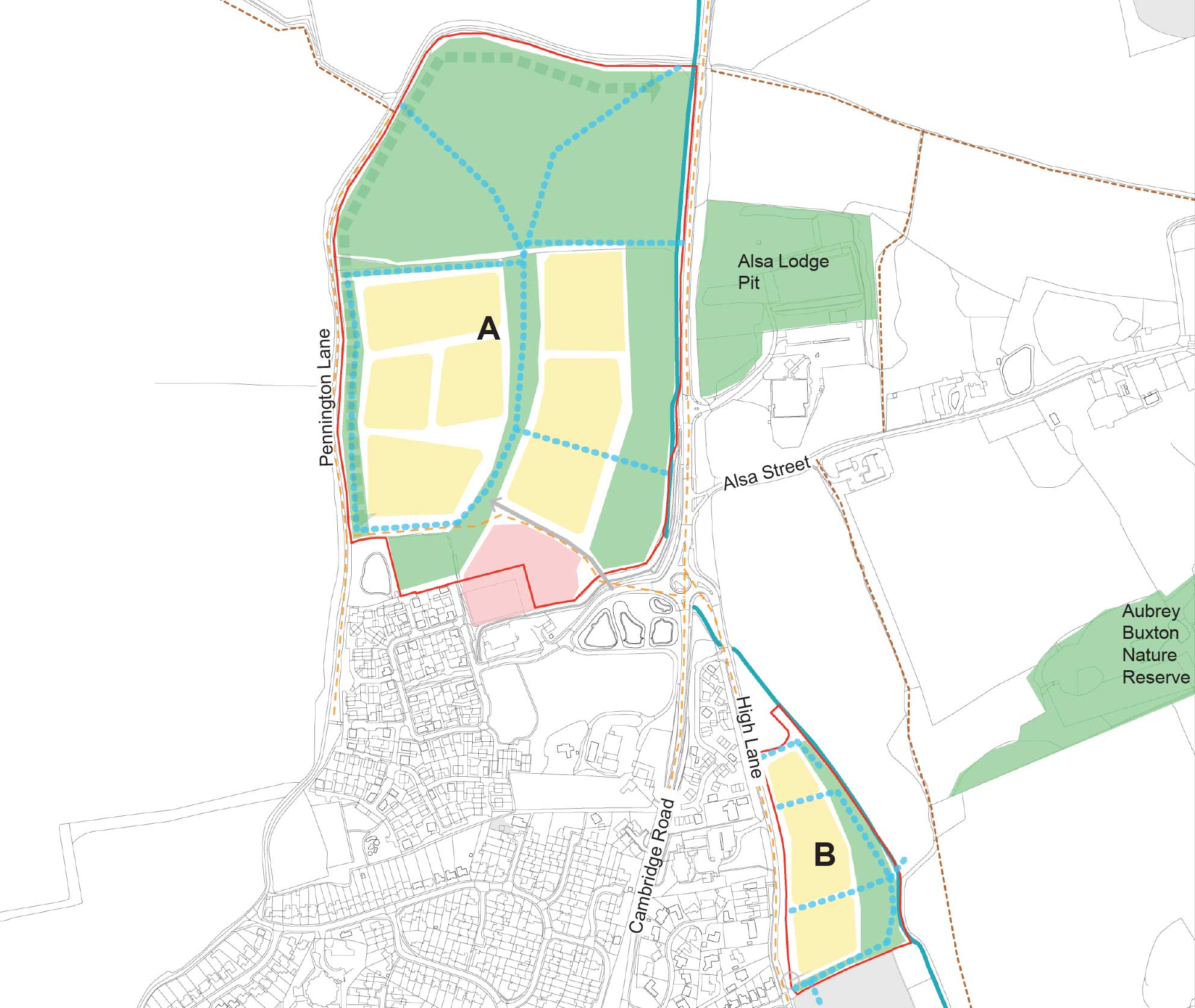
Land East of High Lane, has been identified as a draft allocation within the emerging Uttlesford District Council’s Draft Local Plan which has now been submitted to the Secretary of State for examination.
An extract from the emerging Local Plan of the draft allocation is shown to the right. The inclusion of this site by the Council as part of their growth strategy demonstrates its suitability for development and the sustainability of its location.
Affordable tenures
These proposals will provide 35% affordable housing, which is compliant with Uttlesford District Council’s affordable housing policy.
This will include a mix of affordable tenures, including the provision of social rented and shared ownership, offering a range of options for residents looking to get onto the housing ladder.
 Site Boundary
 Land at Walpole Meadows, East of Pennington Lane
 Land East of High Lane
 Residential Development
 Potential Education Use
 Committed Development
 Open Space/Green Infrastructure
 Vehicle Access
 Pedestrian & Cycle Access
 PROW
PROW Heritage Asset
 Habitat Network
 Sustainable Travel Route
 River
River
Timeline
How the project will move forward with your continued support
Following careful consideration of the responses received through the public consultation, as well as discussions with key stakeholders and Uttlesford District Council, we hope to work towards the proposed timeline:
February 2025
Public consultation event.
March 2025
Feedback collation and review by the project team.
Spring 2025
Submission of planning application to Uttlesford District Council.
Summer 2025
Anticipated determination of planning application.
Spring 2026
Construction to commence on site.
Autumn 2027
Anticipated first new homes completed.